Spatial Distribution
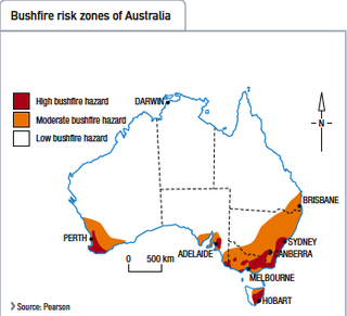
Bushfires are notably common in South Eastern Australia, particularly in Victoria. The hot and dry climate of Australia's summer is prime for the birth of a bushfire. As shown in the diagram on the left, bushfires are most susceptible to occur on the east coast of Australia, particularly in the Great Dividing Range, where huge areas of bushland are present. While spots of Victoria are also dubbed with a high risk of bushfires. In Tasmania, The entire east half of Tasmania is susceptible to the hazard, ranging from a moderate risk to a high risk. In South Australia, the region of Adelaide has a high bushfire risk as well as Perth. However, one must take into consideration that no major bushfire disasters has occurred in recent years. As for the rest of Australia (Darwin, Most of Queensland and Most of Western Australia) do not have a large or moderate risk of bushfires occurring, they simply have a low possibility of it occurring. This is mainly because their simply isn't any bushland or "fuel" for it to occur.
An example of a horrific bushfire is the Victorian Bushfire dubbed "Black Saturday" you can find the link for more information about it here: /
This particular bushfire is considered as a "natural disaster" not a "natural hazard" thus, it has been given the name "Black Saturday". This fire destroyed numerous homes and taken a large amount of lives. The damage it dealt was beyond belief. It occurred on the 7 February 2009, the aftermath is still present in south-east Victoria.
